|
All images and text are copyright protected. Contact
|

 Friendship Highway - Kathmandu to Lhasa In Kathmandu I search the travel agents for ways into Tibet. They are generally the same: expensive jeeps or buses with guide, tours to temples, hotels and travel permits included. Even though I have seen on the Internet that a China visa is sufficient for entry into Tibet, every travel agent insists that travel permits and guided tours are necessary. Travel agents are not any less honest than your average businessman but here the agents, border guards and hotels have a vested interest in keeping the traveler as ignorant as possible. I take a Land Cruiser tour with Silk Road Inc with a maximum of five passengers, driver and guide but in the morning I find that they have booked twelve passengers (too many for two Land Cruisers) and instead, have put us on a bus. A bus tour costs less, but we don't get a refund. I want to insist on a Land Cruiser as arranged but the other passengers are keen to get going.
I have waited ten years to travel in Tibet, The Land of Snows, the Roof of the World, and in 1999 I travelled around the Tibetan Chinese borders hoping for a way in. Those areas have remained more or less unchanged whereas, to create the image that Tibet is an integral part of China, Beijing has pursued a programme of systematically replacing Tibetan culture in Lhasa with Chinese. Today, the resettled Han Chinese in Lhasa outnumber the Tibetans by six to one. Most people will feel the effects of Altitude Mountain Sickness in varying degrees. AMS begins at 2,000 meters, becomes pronounced at 3,500 m and requires adjustments for each 400 m above that. If not treated quickly, it can be fatal. The 1000 km long Friendship Highway, from Kathmandu to Lhasa, goes through seven passes over 3500 meters, four of them rising over 4000 m, one over 5000 m. Two years previously I had suffered from AMS on the eastern edge of the Tibetan Plateau and on this trip I expect it would be the same. We leave Kathmandu at 6 am and drive alongside the whitewater Sun Kosi River which winds through villages set among beautiful, rugged, green hills for 114 km to the Tibetan border at Kodari. The border is chaotic and muddy with dozens of trucks lined up waiting to go through. We wait over one hour on the Friendship Bridge for the Chinese Border Police to inspect our passports and then board a truck which drives up a steep rough trail for 7 km to Zhangmu, the Chinese border town where we again go through formal proceedings. Our Chinese guide has not yet arrived so we must wait here for the night. Zhangmu is a small town with a muddy main street, several hotels, restaurants and shops and not much more. We find a Tibetan restaurant with a jovial manageress and a magnificent view of the valley and while I have a ginger tea with lemon the others have cold Chinese beers. In the morning our guides, a Tibetan ex-teacher and a scruffy young man who speaks very little English, arrive while we are having breakfast and we try to get the Land Cruisers that we have paid for. They have already arranged for two small buses in lieu of the Land Cruisers. Clearly, Silk Road Inc is not interested in good publicity. We leave at 11 am and immediately begin climbing to Nyalam at 3750 m.
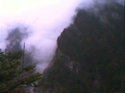
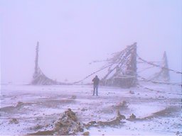
At Nyalam, it begins to snow, at first a flurry, then a blizzard that whites out the sky. The chorten, decorated with prayer flags (lung ta or horses of the wind), is almost obscured by the driven snow.
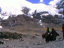
What power drives these Tibetans to erect these chortens in such harsh conditions? Despite my heavy winter clothes, the cold bites into me and I hurry back into the bus. Several passengers complain of headaches, some of tiredness and nausea. The road is, for the most part, dirt or stone, rough and bumpy. The bus is lightly laden and jarring, inducing motion sickness. We sleep in New Tingri, 112 km from the border, in a lonely, Chinese factory guesthouse, 4300 m above sea level. Though I look everywhere I cannot discover what the factory produces. There is no showroom, no stockroom, no waste outside. Outside the guesthouse, on the hill, is a chorten. I want to climb the small hill but feel too breathless in the thin air to attempt the short walk. Two grubby Tibetan boys shyly say "Hallo". They don't speak Mandarin nor English and I don't know many Tibetan words beyond 'Tashi delek'. They offer to sell seashell fossils from here on the Tibetan Plateau which was once under the sea but it is illegal to take fossils out of China. They have a large dog which I pat for a while and rub his stomach. In the night, even with two quilts, it is cold. It is difficult to breathe. I lie awake, shivering, gasping. In the morning, several women are weeping from the effects of AMS and the rough roads: headache, nausea, vomiting, inability to sleep. They want to go back, they want a plane, they want to die. Andy is too weak to walk. Benoit, a bubbly Frenchman, hands out Dymax to help counter the effects.
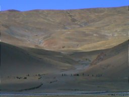
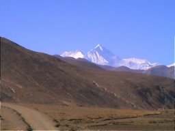
Since ancient times, the Tibetans have called it "Chomolong ma", "goddess, mother of the world". The co-guardian Nepalese say "Sagarmatha", "goddess of the sky". In 1865, totally ignoring these appellations, Sir Andrew Waugh, surveyor general of India, in his double conceit, decided to name a mountain in another country after his predecessor, Sir George Everest. Chomolong ma, at 8848 m the highest mountain in the world, straddles the border between Nepal and Tibet. To the Nepalis, Sagarmatha is sacred. To climb to the peak is sacrilegious, they say, and anyone who profanes her will be forever cursed. Between 1921 and 1996, the peak has been climbed 630 times; 144 bodies are still there. We stand at the roadside and contemplate it. Visually, at a distance of over 80 km, Chomolong ma is not impressive. It looks like just one more snow-topped peak among many. Neighbouring Lhotse stands at 8501 m, Makalu at 8463 m, Cha Oyu at 8153 m. Still, one feels insignificant when dwarfed by the Himalayan Range, these mountains that have stood since the birth of time.
Enthralled by this immense landscape, I sit silently looking out. A lone eagle soars across the limitless skies above, its shadow flitting across the valley floor below. In this thin air, how big must his lungs be to obtain sufficient oxygen? How large must his wings be to keep him aloft? And what of us flitting across the valley floor? We see only the grounded shadows of our real selves soaring high above. There are legends of Tibetan lamas who flew across mountaintops. Here, among these mountains, it seems very possible. The Tibetans have sky burials for their dead where the corpses are left outside for the birds to eat.
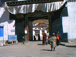
His friend, Guy, less affected by the altitude, has been taking GPS readings. "We want to trek from Tingri to the Everest Base Camp and the GPS will help us find our way." He explains Geographical Positioning System to me, avoiding the technical jargon so that even I can understand. At 6:15 pm, 425 km from Tingri, we stop at Shigatse for the night. For dinner we have Tibetan food which looks exotic but is hardly memorable. Shigatse is a biggish town, Tibet's second largest, with several new hotels, a modern Chinese Post Office, a few Internet cafes and Tashi Lumpo Monastery where the Panchen Lama held office. After his death, his boy incarnation, approved by the Dalai Lama, was instated until his mysterious disappearance. The Chinese appointed a boy Panchen Lama who was not approved by any Tibetan.
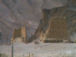
Shigatse looks like a Chinese town with a Tibetan flavour. Only in these towns do we see people up close or see traffic. On the road we encounter perhaps three vehicles a day, jeeps speeding past us or going the other way. I sleep fitfully, a budding headache thumping away at the fringes of my consciousness. At breakfast, all the women are visibly worse. None could sleep, some are crying. Benoit's Peruvian wife, Marcela, looks cheerful but only later in Lhasa would she admit to having felt ill along the way. Shigatse lies at 3900 m, lower than New Tingri, but it hasn't helped We leave Shigatse after lunch and, at 4 pm, arrive in Gyantse, a wild-frontier looking town with dusty streets and a hazy sun which gives the atmosphere of a storm brewing. We go to Baiju Temple, built between 1418 and 1427 by the first Panchen Lama on a hill at the edge of town. Later, we have a tasty Chinese dinner at Zhuang Yuan Restaurant where the owner, like so many other Chinese in Tibet, is from Sichuan. I walk the streets looking into shops: buckets and nails; cloth and clothes; saddles, bridles and ropes; shoes, boots and cowboy hats; canvas awning and sheet plastic; and at the end of the street is a butcher.
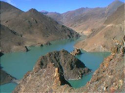
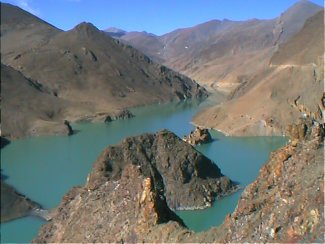
Then we are over the last pass, Kamba la Pass, at 4794 m and descending into a green valley with orchards and fields irrigated by the Kyichu River. The lush colours are a feast for the eyes after four days of driving through dry brown desert. The road here is tarmac and indicates we are approaching civilization. We go across a dam and then we are in Lhasa. Astronauts or sailors probably feel this way, returning to earth after a measureless time in space. I look in wonderment at trucks and vans, people and buildings, amazed that they exist. After three days in Lhasa I take a Land Cruiser back to Zhangmu on the Nepalese border. This is a no stops, no frills, just plain drive to the border. The driver is a Tibetan cowboy who drives quickly leaving a plume of dust behind but who is unable to change a flat tyre. Abraham, a 57-year-old Israeli has to do it for him. On the first day we cover 585 km to Lhatse where we sleep in a truck stop dorm where the lights are so dim I need a torch to find the light switch. We retrace the same route but the Land Cruiser is smoother than the bus on the rough road and there is no motion sickness. Even the weather is kinder, no snow and temperatures are mild. We stop at checkpoints along the way for forty, fifty, sixty minutes, but for what reason? We are going out of Tibet. Guy and Yong are in another Land Cruiser also going to Nepal. At the checkpoints we meet again. "How's the head?" I ask Yong. "It's alright, I guess," he says. But I am not sure he means it. "Are you still going trekking to the Everest Base Camp?" I ask. "They won't allow us to go alone," Guy replies. "They insist we hire a jeep, driver and guide. It's too expensive. We're going back to Kathmandu."
We arrive in rainy Zhangmu at 5 pm and leave the Land Cruiser. We go through the Chinese border and Abraham and I hire a small jeep to take us to Kathmandu. In Kodari, a Nepalese second visa costs USD 50 for one month, no haggling, fixed price, they tell Abraham who resents having to pay so much. A bus has stopped midway on a bridge blocking traffic which causes a halt for over one hour. It is a political protest but we are not told why. Abraham brings me dinner, cheap, tasty and filling. The jeep has a flat tyre and we stop in a wet, soggy village outside Kathmandu for over two hours to fix it. The night is warm, humid, languid and dark from an electrical power cut and some shops are using candles. In the street, the children use flashlights and candles to attract rainflies which they put into bottles. In the candlelight, the rainflies swirl like a blizzard. Raceandhistory.com | Howcomyoucom.com | Trinicenter.com | TriniView.com Another 100% non-profit Website serving poorly represented communities. Copyright & Disclaimer. - - Privacy Policy --Designed & maintained by S.E.L.F. © 2002 TriniView.com |